CROXLEY GREEN - WATFORD HIGH STREET (Pt.1)

(1912 - 1996)

This branch line was opened by the London & North Western Railway (LNWR) to provide competition with the Metropolitan line, whose influence was in the ascendancy in north-west London. The line branched off the ill-fated Watford - Rickmansworth line, opened originally by the Watford and Rickmansworth Railway (and which was absorbed into the LNWR only nineteen years after opening).

The main Rickmansworth line was closed to passengers in 1952, its demise caused by a familiar pattern of more direct and cheaper services elsewhere. The Croxley Green branch somehow survived Beeching's axe but attempts to create more traffic by providing more frequent services failed. The line was closed unofficially in 1996 when a new dual carriageway cut through the embankment that carried the line and a new replacement bridge was deemed as not being financially viable. Formal closure was passed in 2002, albeit with the long-term intention of the line being taken over by the Metropolitan Line.

The long-term intention of re-opening the branch seems destined to remain as just that. Despite spending £71 million so far (on what?) the line is no nearer to being rebuilt. The authorisation that was granted for the rebuilding of the line expired in 2018 and with escalating costs and a lack of agreement for the funding, it is suspected that the line will remain a disused one for a long time to come.

Details of the plans up to 2015 are contained in this excellent site: www.croxleyraillink.com. A more recent explanatory article is available from London Reconnections.


CROXLEY GREEN STATION

For a map of the station, click here.


The roundabout where Croxley Green station is located (arrowed). The new bridge intended to connect the Metropolitan line with the Croxley Green branch would have been built going from left to right behind the roundabout and the old station. The connection point wouldn't have been at Croxley Green station, which will remain closed and disused regardless of the extension going ahead or not, but further east, just shy of the new proposed station at Ascot Road.

(photo: Jan 2012)


Taken from the same position as the photo above but zoomed in.

(photo: Jan 2012)


Press Refresh or Load Image if the image doesn't appear


The terminus at street level. The red lamposts in the photo to the left of the information sign, indicate the path up to the platform. The information board has never had any information on it to indicate that the station is closed and where the nearest alternative stations are.

(photo: 2001)


Press Refresh or Load Image if the image doesn't appear


For a while, passengers wishing to reach this station could still order tickets to it but a rail-replacement-cab would have to be ordered for them (presumably from Watford High Street station). A protest at the line's closure would have been interesting, if the number of people it would take to fill a train simultaneously demanded tickets to this station.

(photo: 2001)


Signage still in situ in 2010.

©2010 Stephen Golding


The station on the left and the only sign of habitation - the pub - on the right.
The station did have a street level station building but it was demolished in the 1960s to allow for road widening.

(photo: Dec 2005)


The street signage for the station was removed sometime in 2013/2014.

(photo: Aug 2020)


The staircase up to the platform area in a rare state of not being completely overgrown.

(photo: Dec 2005)


The staircase looking down toward street level.

(photo: Dec 2012)


The station with its original platform and building while still in use. This is an eastward view.

(Photo: Dec 1976)   © Mark Dufton


The station with its original platform. Another eastward view. The Sun Printing site is on the left and the bridge taking the line over the canal is just beyond the end of the platform.

(Photo: Apr 1976)   © Mark Dufton


The station with its original platform. The site was moved eastward slightly due to the widening of the A412 and the platform was rebuilt on the other side of the track.

© Richard Allen


Westward view (similar to above). The original platform was located on the right. The concrete supports are still visible, albeit mostly covered in ivy. The replacement platform was located on the left hand side; one of its lamp posts is still just about visible.

(photo: Jan 2012)


Westward view of the end of the line. The tracks veering off to the left are heading toward the goods area.
The area seen here was cut back to allow for expansion of the road beyond it.

(photo: 1957 by J.J. Davis, from author's collection)


Westward view of the truncated end of the line. The walkway down to street level is hidden by the foilage on the right.

(photo: Jan 2012)


Press Refresh or Load Image if the image doesn't appear


An earlier westward view from the photo above showing the newer replacement platform still in situ.

(photo: 2001)


Press Refresh or Load Image if the image doesn't appear


Westward view again but at the end of the platform furthest away from the entrance. The construction is of a basic and temporary nature.

(photo: 2001)


Dec 2005 and the makeshift platform has been removed completely. The staircase to street level is behind the barrier on the left.


Eastward view in August 2020. One of the red lamposts has fallen over across the track and is just about visible on the right of the photo.


Press Refresh or Load Image if the image doesn't appear


Westward view of the track beyond the station but facing back toward it. In fact this area was part of the original station with its longer platform - the ivy covered concrete supports are on the right hand side of the track.

(photo: 2001)


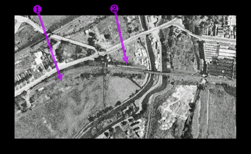
Two aerial views courtesy of Google Earth:

The top level dates from 1947, the lower level (moving your cursor over the image) from 2000 or so.
Some points of interest:

1- The goods yard that was served by the line. The tracks continued westward beyond Croxley Green station.
2- Croxley Green station.
3- The part of the embankment that was removed in 1996 to allow for the construction of a new dual carriageway running parallel with Ascot Road.


Part 2: Croxley Green to Ascot Road